Hurricane Preparedness

Notice: For response information on a currently active storm, visit the Storm Response Information page.

Annual Hurricane Conference

Hurricane-Conference-Slide-Slide.jpg

On Thursday, May 28, 2026, the Town will once again offer the yearly reminder that "preparedness is better than panic" as it hosts the 2026 Hurricane Conference in the Council Chambers, located on the second floor of Town Hall at 4601 E Oak Island Dr.

Doors will open at 5:00 PM for the Resource Fair, with Presentations scheduled to begin at 6:00 PM.

Coordinated by the Oak Island Police Department, this year's conference looks to be bigger and better than ever! Multiple Town Departments and partner agencies will be represented through presentations and a Panel Discussion, as well as a Resource Fair featuring response agencies and private services vendors.

QUESTIONS The conference will feature a Panel Discussion, with Town Staff answering common questions regarding preparation and response to hurricanes. To help ensure the conference remains on schedule, questions must be submitted through the link below by 5:00 PM on Monday, May 25.

CLICK HERE TO SUBMIT QUESTIONS


Hurricane Preparedness & Response

During threats of severe weather from hurricanes, tropical storms or other coastal weather hazards, it's important to know how the TOWN will prepare and response, as well as how YOU should personally prepare and respond

Please take a few minutes to review the information below, to learn about hurricane preparedness in Oak Island, before the next storm threatens.

Know Your Risk

Know Your Risk Where You Live

Find out today what types of wind and water hazards could happen where you live. Hurricanes are not just a coastal problem. Impacts from wind and water can be felt hundreds of miles inland, and significant impacts can occur regardless of the storm’s strength. Know if you live in an area prone to flooding, if you live in an evacuation zone, and identify any structural weaknesses in your home.

Consider Your Threats

While hurricanes pose the greatest threat to life and property, tropical storms and tropical depressions also can be devastating. The primary hazards from tropical cyclones (which include tropical depressions, tropical storms, and hurricanes) are storm surge flooding, inland flooding from heavy rains, destructive winds, tornadoes, and high surf and rip currents.

Storm surge is water that is pushed toward the shore by winds swirling around the storm, and historically has caused the largest loss of life in hurricanes. This rise in water level can cause severe flooding in coastal areas, which can submerge entire areas, cause structural damage to buildings, and wash out roads. Storm surge can travel several miles inland, especially along bays, rivers, and estuaries.

Flooding from the extreme amounts of rain a hurricane can bring has also proven to be very deadly, both over an extended period of time as well as very short-term flash flooding. Homes and businesses could flood, and flooded roads could make travel and evacuations difficult, as well as being a potentially deadly hazard to those in vehicles or on foot. Floodwaters can also contain harmful bacteria, chemicals, wildlife and other dangerous objects. Extreme rain from hurricanes can even flood areas that aren’t normally prone to flooding. Flooding can happen hundreds of miles inland, and can persist for several days after a storm.

Hurricane-force winds can cause damage to homes and other buildings, ranging from moderate to catastrophic depending on both wind speed and structural integrity. Wind damage can lead to large areas with power and communications outages, as well as uproot trees and make roads impassable due to debris. Signs, roofing material, and other items left outside can become flying missiles during hurricanes. Mobile homes are especially vulnerable to wind damage.

Hurricanes and tropical storms can also produce tornadoes. These tornadoes most often occur in thunderstorms embedded in rain bands well away from the center of the hurricane; however, they can also occur near the eyewall.

Waves from distant storms can produce deadly rip currents and rough surf on beaches very far away. Good weather at the beach itself does not mean the ocean is safe. Even storms more than 1,000 miles away can cause impacts.

Why should I not focus on the category alone?

The Saffir-Simpson Scale is a wind scale that uses wind only to estimate potential damage. Unfortunately this scale does not tell you about all of the impacts that a hurricane can produce. It does not tell you how much rain will fall or how high the storm surge may be. It does not tell you anything about potential impacts from tornadoes or rip currents. It also does not give you information on how large the storm may be, or anything about the storm's movement. In fact, water accounts for 90% of direct deaths from tropical systems, both from storm surge and flooding rain. Please keep this in mind this upcoming season. Pay attention to all of the impacts from a storm and not just the category. Remember that Hurricane Florence was "just" a category 1 when it made landfall along our coast.

Determine if You Live in a Flood-Prone Area

Anyone living in a flood-prone area is especially vulnerable to hurricane impacts. Find out today the flood risk for your area and plan accordingly. If you don’t live in a flood zone, that doesn’t necessarily mean you’re safe - extreme rain from hurricanes can bring floods even to areas that aren’t prone to flooding.

Identify Your Home's Structural Risks

Find out if your home has any weaknesses that could prove deadly in a hurricane. Are your exterior doors and garage door hurricane proof? Do you have storm shutters? Some aspects of your home can be strengthened to help withstand hurricane impacts, and some can not. Mobile homes are especially vulnerable to hurricane-force winds, and basements are especially vulnerable to storm surge and flooding.

When Is Hurricane Season?

The most active months for tropical systems in North Carolina are August, September and October. However, hurricanes have impacted our state as early as May and as late as November! The peak tropical activity usually occurs in a six week period from mid-August to late September, during which time our state can experience multiple hurricanes or tropical storms within weeks of each other.

Prepare Before the Season

The best time to prepare is before hurricane season begins. Avoid having to rush through potentially life-saving preparations by waiting until it’s too late. Get your disaster supplies while the shelves are still stocked, and get that insurance checkup early, as flood insurance requires a 30-day waiting period.

Develop an Evacuation Plan

If you are at risk from hurricane impacts, you need an evacuation plan. Now is the time to begin planning where you would go and how you would get there. You do not need to travel hundreds of miles. Your destination could be a friend or relative who lives in a well built home outside flood prone areas. Plan several routes. Be sure to account for your pets. If you don’t have a vehicle, check with local officials to see what transportation options they may have available.

Assemble Disaster Supplies

Whether you’re evacuating or sheltering-in-place, you’re going to need supplies not just to get through the storm but for the potentially lengthy and unpleasant aftermath. Have enough non-perishable food, water and medicine to last each person in your family a minimum of 3 days (store a longer than 3-day supply of water, if possible). Electricity and water could be out for weeks. You’ll need extra cash, a battery-powered radio and flashlights. You may need a portable crank or solar-powered USB charger for your cell phones. And lastly, don’t forget your pets!

FEMA: Build a Kit

Get an Insurance Checkup & Document Your Possessions

Call your insurance company or agent and ask for an insurance check-up to make sure you have enough insurance to repair or even replace your home and/or belongings. Remember, home and renters insurance doesn’t cover flooding, so you’ll need a separate policy for it. Flood insurance is available through your company, agent, or the National Flood Insurance Program at floodsmart.gov. Act now, as flood insurance requires a 30-day waiting period. Take the time before hurricane season begins to document your possessions: photos, serial numbers, or anything else that you may need to provide your insurance company when filing a claim.

Create a Communication Plan

Take the time now to write down your hurricane plan, and share it with your family. Determine family meeting places, and make sure to include an out-of-town location in case of evacuation. Write down on paper a list of emergency contacts, and make sure to include utilities and other critical services — remember, the internet may not be accessible during or after a storm.

FEMA: Make a Plan

Strengthen Your Home

Now is the time to improve your home’s ability to withstand hurricane impacts. Trim trees. Install storm shutters, accordion shutters, and/or impact glass. Seal outside wall openings. Remember, the garage door is the most vulnerable part of the home, so it must be able to withstand hurricane-force winds. Many retrofits are not as costly or time consuming as you may think. If you’re a renter, work with your landlord now to prepare for a storm. And remember - now is the time to purchase the proper plywood, steel or aluminum panels to have on hand if you need to board up the windows and doors ahead of an approaching storm.

FEMA: Tips to Prepare Your Home for Hurricane Season

Storm Surge

One of the greatest potentials for loss of life related to a hurricane is from the storm surge. Storm surge is simply water that is pushed toward the shore by the force of winds swirling around the storm. This advancing surge combines with the normal tides to create the hurricane storm tide, which can increase the mean water level to heights impacting roads, homes and other critical infrastructure. The shape and orientation of our coastline put's us at risk for storm surge. Most recently we saw devastating storm surge from both hurricanes Florence and Dorian.

Know Your Zone

Know Your Zone is a cooperative effort of North Carolina Emergency Management and county emergency management partners in coastal counties. After being piloted during the 2019 hurricane season, state and county emergency emergency management has partnered to officially launch the initiative for the 2020 hurricane season.

North Carolina Know Your Zone is a tiered evacuation system that highlights areas most vulnerable to impacts from hurricanes, tropical storms, and other hazards. If it becomes necessary, local officials will order evacuations using pre-determined zones created by coastal counties. The Know Your Zone lookup tool is a new color-coded interactive map you can use to determine the evacuation zone where you live, work, or are visiting based upon your street address.

Evacuation zones highlight areas most at risk to storm surge and flooding. Local officials will determine which areas should be evacuated. Areas in Zone A will typically be evacuated first, followed by areas in Zone B, etc. While all zones won’t be evacuated in every event, emergency managers will work with local media and use other outreach tools to notify residents and visitors of impacted zones and evacuation instructions.

Please take some time this week to read more about Know Your Zone in preparation for this launch and coming hurricane season. To access the lookup tool and other resources, please visit the website by clicking on the image below.

Understand Forecast Information

National Weather Service forecast products can tell you a lot about what is expected to happen with a storm, including the storm’s paths, rainfall amounts, wind speeds, and more. There is a lot of information available days ahead of a storm, and it is important to understand what it means.

Have Trusted Sources for Storm Information

Rely on official forecasts and well-established media partners in the Weather Enterprise. Be cautious of sensational headlines and instead look for reliable sources to determine a storm's potential impacts. Use the official National Hurricane Center Forecast — their hurricane specialists access a variety of data (models, aircraft, satellite) to make the most accurate forecasts possible. Meteorologists at local NWS offices understand which locations in your area are most vulnerable to storm surge, flooding, and wind. Always check to make sure you have the latest forecast information. Make sure to have Wireless Emergency Alerts enabled on your phone to receive Warnings.

Know Your Alerts & the Difference Between a Watch & Warning

In general, a Watch means impacts are possible; a Warning means impacts are expected or happening. Different hazards and alerts require different responses:

  • A Hurricane Watch means hurricane conditions are possible somewhere within the watch area, with tropical-storm-force winds beginning within the next 48 hours. Prepare by boarding up windows and moving loose items indoors, and make sure your emergency kit is ready. A Hurricane Warning means hurricane conditions are expected somewhere within the warning area, with tropical-storm-force winds beginning within 36 hours. Seek shelter in a sturdy structure or evacuate if ordered.
  • A Tropical Storm Watch means tropical storm conditions are possible within the next 48 hours. A Tropical Storm Warning means they are expected somewhere within the warning area. Remember, a tropical system does not have to reach hurricane strength to be deadly.
  • A Storm Surge Watch means the possibility of life-threatening inundation generally within 48 hours, and a Storm Surge Warning means the danger of life-threatening inundation generally within 36 hours. In either case, please promptly follow evacuation and other instructions from local officials.
  • An Extreme Wind Warning means extreme hurricane winds (115 mph+) are imminent or happening: take immediate shelter in an interior portion of a well-built structure.
  • A Flash Flood Warning means dangerous flash flooding is expected: move to higher ground, and never walk or drive through floodwater. A Flash Flood Emergency is issued for exceedingly rare situations when a severe threat to human life and catastrophic damage is happening or about to happen — do not attempt to travel unless you are under an evacuation order or your life is imminently at risk.
  • A Flood Watch means flooding is possible: stay tuned to trusted news sources and be ready to seek higher ground. A Flood Warning means flooding is happening or about to happen: move to higher ground immediately.
  • A Tornado Watch means a tornado is possible: know your safe place and be ready to act quickly if a Warning is issued. A Tornado Warning means a tornado is happening or about to happen - immediately seek shelter in your safe place!

Deadly Hazards Occur Well Outside of the Cone

Impacts can be felt far from the storm's center, even well inland and outside the Forecast Cone. Remember: the storm itself can stretch well beyond the Forecast Cone, and so can the impacts. The National Hurricane Center Forecast Cone shows the probable forecast track of the center of the storm. This means that the storm’s center will probably travel somewhere within the cone’s boundaries. (Historically, the storm’s center has remained within the forecasted cone roughly two-thirds of the time.) The cone does NOT represent the size of the storm in any way.

NHC Video: How to use the cone graphic

Get Moving When a Storm Threatens

When a storm is forecast to impact your area, take action immediately to be ready. Ideally, longer-term preparedness actions such as having disaster supplies and an evacuation plan will have already been done before hurricane season, when the stores are stocked and time is on your side. When a storm threatens, there’s a lot more to do..
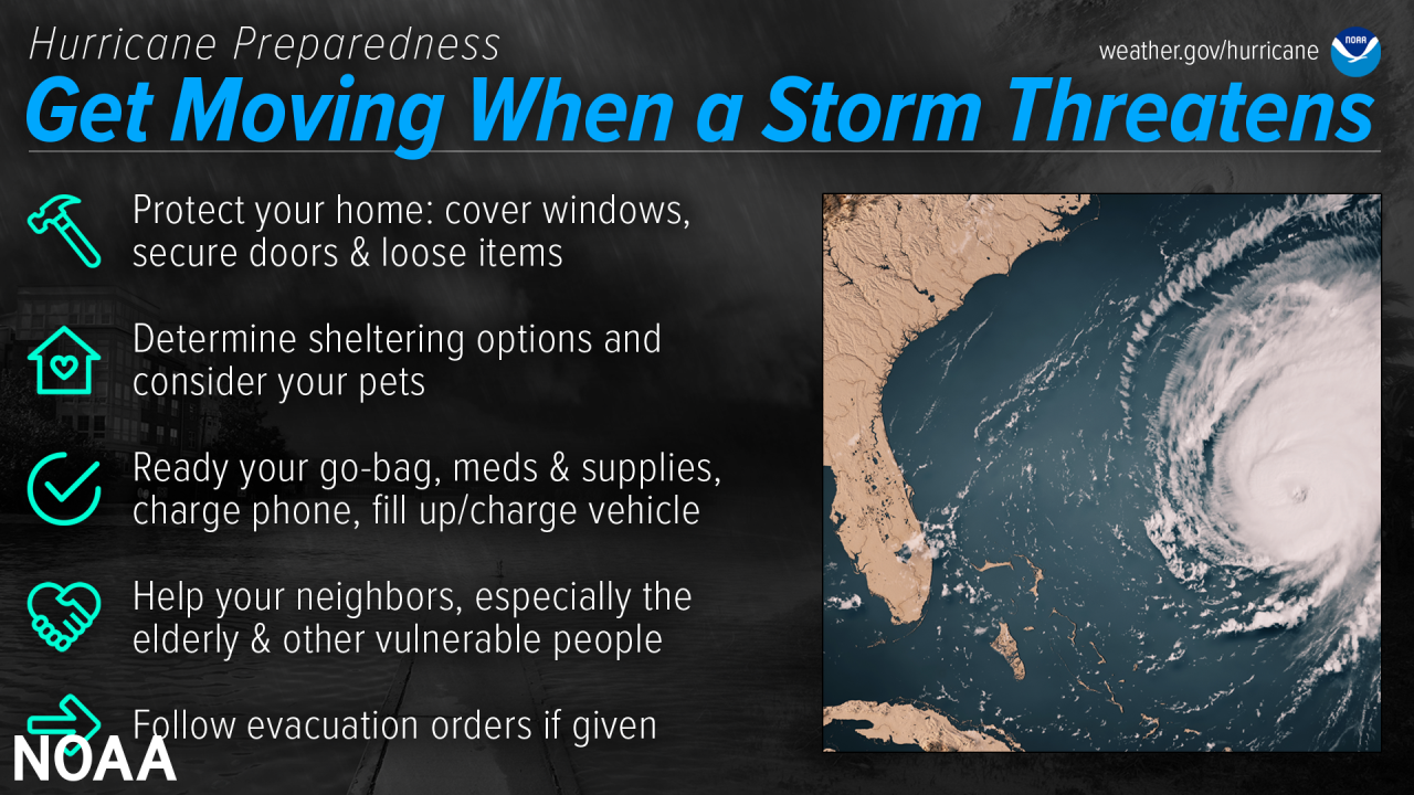
Protect Your Home

While longer-term home improvement needs to be done well ahead of time, when a storm threatens there are short-term actions to help protect your property. Board up windows, secure loose outdoor items, and secure all exterior doors. Move your vehicle to a safe location if you’re not using it to evacuate. If you are evacuating, unplug electrical equipment such as radios, televisions and small appliances (freezers and refrigerators also need to be unplugged if there is a risk of flooding). If you are instructed to do so, shut off water, gas and electricity before leaving.

Here are some tips for preparing and strengthening your home for tropical storms and hurricanes:

  • Keep trees around hour home trimmed well before a storm to prevent damage from broken branches.
  • Shop now for tested and approved window coverings to put up when a hurricane approaches.
  • Bring loose outdoor items, such as patio furniture, inside. They can blow around and cause damage to homes.
  • Secure all doors on your property. Remember that garage doors are the usually the most vulnerable.
  • Move your car inside a garage or to another secure location.
  • For more information about strengthening your home, please visit flash.org.

How-To: Protect Your Home in a Flash

Determine Sheltering Options & Consider Your Pets

While longer-term home improvement needs to be done well ahead of time, when a storm threatens there are short-term actions to help protect your property. Board up windows, secure loose outdoor items, and secure all exterior doors. Move your vehicle to a safe location if you’re not using it to evacuate. If you are evacuating, unplug electrical equipment such as radios, televisions and small appliances (freezers and refrigerators also need to be unplugged if there is a risk of flooding). If you are instructed to do so, shut off water, gas and electricity before leaving.

Download the FEMA App to find local shelters

Ready Your Go-Bag, Meds & Supplies, Charge Phone, Fill Up/Charge Vehicle

Have a go bag ready to take things with you if you need to leave in a hurry. In addition to basic survival needs, don’t forget other supplies such as chargers and hygiene products. Plan to have enough for at least three days, and don’t forget about your pets. While preparing these basic needs, don't forget to keep your phone charged, and make sure to fill up/charge your vehicle as well. Your go-bag should also contain important personal and property documents, including your written communication plan.

Help Your Neighbors - Especially the Elderly & Other Vulnerable People

Many people rely on their neighbors before and after a disaster, and there are many ways you can help them. Help them prepare for a storm, and help them evacuate if needed. Share the latest forecast information with your community so that they know what to expect.

Follow Evacuation Orders If Given

Always follow evacuation orders from local authorities — don’t wait for a hurricane to intensify before deciding to follow the order. You want to leave early enough to avoid being trapped by severe weather. If time allows, unplug electrical equipment, leave a note detailing your whereabouts, and check to see if any neighbors need a ride.

Inland Flooding

Inland flooding is the most deadly and serious threat hurricanes bring to inland areas of North Carolina. Hurricane Matthew in October 2016 generated record flooding across much of the coastal plain of North Carolina, claimed 28 lives, and left thousands homeless and entire towns under water. More recently, Hurricane Florence once again produced devastating inland flooding, and resulted in 11 flood-related deaths in North Carolina. Overall, most hurricane deaths over the past 30 years have been the result of flooding, many of which have occurred in automobiles as people attempt to drive through flooded areas where water covers the road. It is important to realize the amount of rain a tropical system produces is not related to the intensity of the wind. Weak hurricanes and even tropical storms have caused disastrous floods throughout history.

So what can you do? Anytime a hurricane or tropical storm threatens, think flooding. It is very important to determine if you live in an area at risk of flooding. If your yard or nearby roads around your home flood during ordinary thunderstorms, then you are at serious risk of flooding from torrential tropical rainfall. Those living near creeks, streams and drainage ditches should also closely watch water levels. Remember, extreme rainfall events bring extreme flooding typically not experienced in the past. During extreme events even those area which normally do not flood are at risk.

Always stay aware of road conditions and make sure your escape route is not becoming flooded by heavy rain. Never attempt to cross flowing water; instead, remember to turn around, don't drown. The reason that so many people drown during flooding is because few of them realize the incredible power of water. A mere six inches of fast-moving flood water can knock over an adult. It takes only two feet of rushing water to carry away most vehicles. This includes pickups and SUVs. Never allow children to play near streams, creeks or drainage ditches. As rain water runs off, streams, creeks, and ditches fill with running water that can easily sweep a child away.

Stay Protected During Storms

During a storm, whether you’ve evacuated or are sheltering in place, know what to expect from the hazards you may face. Remain vigilant, stay up-to-date with the latest forecasts and alerts, and continue to listen to local officials.

Stay in Your Safe Places From Water & Wind

Always keep a safe distance from flooded and damaged areas. When you’re at risk from storm surge or flooding, it’s important to get to high ground away from bodies of water and any flood-prone areas. Evacuate if told to do so. Never drive through floodwaters or compromised bridges. Always pay attention to barriers and signage.

If your house becomes flooded and you’re still there, get higher in your house to escape the flood waters. If the highest floor of your home becomes dangerous, get on the roof and call 911.

Though rain and storm surge cause more direct deaths, wind can also be very destructive and deadly in hurricanes. Winds can be stronger higher above ground level. This can put high-rise buildings at a greater risk. To protect yourself from wind, the best thing you can do is put as many walls as possible between you and the outside. An interior room without windows is the safest place you can be in a building. You can cover yourself with a mattress and wear a helmet for added protection. If your area is under an Extreme Wind Warning, take shelter immediately. Make sure to stay sheltered until the threat is gone.

Have a Way to Get Weather Alerts & Forecast Updates

Make sure to have Wireless Emergency Alerts enabled on your phone to receive Warnings and other alerts. Always pay attention to the latest forecast as conditions can change quickly and storms can rapidly intensify from a tropical storm to a major hurricane. Even small changes in the storm’s track can make a big difference.

Keep in Mind That Impacts Can Be Felt Far from the Coast

Remain vigilant even if you’re far from the most damaging winds. Inland flooding can be felt hundreds of miles from the coast. Never drive through floodwaters! A car can be swept away with only a foot of water, and there’s no way to know if the road itself has collapsed when hidden by water.

Listen to Local Officials & Avoid Travel Unless Ordered to Evacuate

Local officials can provide you with up-to-date information as the situation changes in your area. Evacuation orders may still be given at this late stage — leave immediately if ordered! Follow recommended evacuation routes — do not take shortcuts, as they may be blocked. Be alert for road hazards such as washed-out roads or bridges and downed power lines. Never drive through floodwaters.

Tornadoes

Any tropical system is capable of producing tornadoes! Tropical tornadoes are often short lived but they can produced enhanced areas of damage. Sometimes these tornadoes can occur in the outer rain bands, well ahead of the center of the storm. In 2019 Hurricane Dorian produced an EF-2 tornado in Emerald Isle, NC with estimated winds of 115 MPH. In 2018, Hurricane Florence produced 27 tornadoes in North Carolina! To prepare for the possibility of tornadoes it's important to have multiple ways to receive warnings, so you can seek shelter quickly if a warning is issued for your area.

Use Caution After Storms

Dangers remain even after the skies turn blue. This is not the time to put your guard down. Nearly half of hurricane fatalities occur after the storm.

If You Evacuated, Only Return Home Only When Told to Do So

Return home only when officials say it is safe. Check with local officials both where you’re staying and back home before you travel.

Remain Vigilant, As Hazards Remain

  • Be careful near damaged buildings. Walk carefully around the outside of your home to check for loose power lines, gas leaks, and structural damage, including dangerous debris such as nails or glass. Leave your home if there’s shifting or unusual noises. If you smell gas, get outdoors immediately and call 911.
  • Avoid electric shock by staying far away from downed power lines. Stay alert: they may be on the ground, hidden in water, or dangling overhead.
  • Flooded roads are very dangerous. It can be difficult to judge how deep or swift the water is moving — just 12 inches of water can float a car. Never drive through flooded roads, even if you are seeking supplies or trying to check on someone. Floods can also compromise bridges and roads. Avoid flooded river areas, as they can continue to rise long after a storm passes. - Don’t walk in floodwaters, either — they can contain harmful bacteria, chemicals, sharp objects, and dangerous animals.

Clean Up Safely: Don't Push Yourself, and Check on Neighbors

Stay hydrated, wear light, loose-fitting clothing, and clean up during cooler hours if possible. Don’t push yourself: straining the body can lead to heart attacks, heat strokes, and other serious issues. Perform cleanups slowly, taking lots of breaks. Make sure to check on your elderly neighbors and other vulnerable people in your community. If your area is under a Heat Advisory, use extreme caution and consider cleaning up when the heat has subsided.

Practice Portable Generator Safety

Be very careful with portable generators: carbon monoxide poisoning is one of the leading causes of death in areas dealing with power outages. Never use a generator inside your home or garage, even if doors and windows are open. Only use generators outside, more than 20 feet away from your home, doors, and windows.

Help and Communications May Not Be Readily Available

After a hurricane, emergency responders may be overwhelmed. Be aware that it could take hours or days for them to reach your area. Communication systems may be impacted, and making phone or video calls might be difficult due to network congestion. If possible, communicate via text, email, or social media.

Rip Currents

Even when hurricanes stay out at sea, the North Carolina coast can still be impacted by large swells and deadly rip currents, thus making it important to stay aware of the tropics and weather forecasts all throughout the hurricane season. Rip currents are channelized currents of water flowing away from shore at surf beaches. Rip currents are quite common and can be found on many surf beaches every day. They typically form at breaks in sandbars, and also near structures such as jetties and piers. While the risk of rip currents occurring along the North Carolina beaches increases when a tropical cyclone is out in the Atlantic, the risk increases even more so when a tropical cyclone is moving toward the North Carolina coast, especially when the storm is a day or two away from making landfall along the Carolina coast.

Rip currents are dangerous because they can pull people away from shore. Rip current speeds can vary from moment to moment and can quickly increase to become dangerous to anyone entering the surf. Rip currents can sweep even the strongest swimmer out to sea. Some clues that a rip current may be present include a channel of churning, choppy water, a difference in water color, a break in the incoming wave pattern, and a line of foam, seaweed or debris moving seaward.

If you find yourself caught in a rip current, stay calm and don’t fight the current. Escape the current by swimming in a direction following the shoreline. When free of the current, swim at an angle—away from the current—toward shore. If you are unable to escape by swimming, float or tread water. When the current weakens, swim at an angle away from the current toward shore. If at any time you feel you will be unable to reach shore, draw attention to yourself: face the shore, call or wave for help. Also, don’t become a victim while trying to help someone else! Many people have died in efforts to rescue rip current victims. Instead, get help from a lifeguard. If a lifeguard is not present, yell instructions on how to escape. If possible, throw the rip current victim something that floats. Call 9-1-1 for further assistance.

Take Action Today

Are you ready for hurricane season? Take action today to be better prepared for when the worst happens. Understand your risk from hurricanes, and begin pre-season preparations now. Make sure you understand how to interpret forecasts and alerts, and know what to do before, during, and after a storm. Even if you are already well-prepared and knowledgeable, there may be additional things you could do or learn to be even more prepared

Bridge Closures & Re-Entry

The Town of Oak Island is serviced by two main bridges; on the East end by the the G.V Barbee Sr. Bridge (NC 133 / Long Beach Rd SE), and on the West end by the Swain's Cut Bridge (NC 906 / E.F. Middleton Blvd.). Click the tab below for more information on the procedures and response plan, should conditions become dangerous enough to require bridge closures.

Bridge Closure, Access, & Re-Entry

Every storm is different. With the Town’s unique geography and location along the coast, it would be impractical to apply the same response to every storm.

That is why Oak Island has developed a multi-level Storm Response & Recovery plan, which can be adapted to meet challenges ranging from Island-wide disaster to street-level closures.  

In any Response & Recovery effort, the primary goal remains the same: Protect lives and infrastructure during an event; and ensure recovery as quickly and safely as possible.

BRIDGE CLOSURES

Oak Island is serviced by two bridges:

  • G.V. Barbee Bridge (NC 133 / Long Beach Road)
  • Swains Cut Bridge (NC 906 / E.F. Middleton Blvd)

BRIDGES WILL ONLY CLOSE when wind or weather conditions make safe travel dangerous!

Unless catastrophic damage occurs, bridges will be reopened as soon as conditions allow for safe travel.

Typically, this is when sustained windspeeds reach or exceed 40 MPH, or during similar threatening conditions. If the bridges are going to close, the Town will provide as much Public Notification in advance as possible.

Closures will be marked with physical signage posted on traffic barriers, placed at the base of each bridge.

In the event of widespread catastrophic damage to the entire island, bridges may remain CLOSED until the area can be properly assessed for safe re-entry; with access restricted to emergency personnel ONLY

RE-ENTRY for everyone would begin as soon as access and travel is deemed safe.

  • NOTE: Decals or physical Stickers / Passes are NOT used for re-entry; however, identification and homeowner’s documents should be included in ANY evacuation kit, as these items may be needed during recovery efforts.  

Catastrophic Damage requiring an extended bridge closure can include:

  • Bridge Damage / Needed Inspections
  • Exposed or Open Utilities (electrical / sewage)
  • Damaged / Collapsed Buildings & Infrastructure
  • Island-wide Contamination / Public Health Concerns

ZONE & STREET CLOSURES

NEVER travel around barricades or enter any closed streets! This is dangerous for everyone and can delay recovery efforts!

Individual areas of the Island may experience different levels of impact from a storm. Rather than limit access to the entire Island through bridge closures, access will be controlled for specific Zones or Streets as needed. These sections of Town may remain inaccessible for longer periods of time during a recovery.

Zone / Street closures can result from several factors, including:

  • Street Flooding
  • Utility Service Disruptions
  • Damaged / Blocked Infrastructure
  • Structural Instability
  • Contamination / Health Concerns

For damage to individual areas or properties, Zone & Street Closures will be established using physical signage posted on traffic barriers, placed at a safe distance. During a closure, access within these areas will be restricted to emergency personnel ONLY. Access for everyone would resume as soon as travel, Infrastructure, and utilities in the area is deemed safe.

PUBLIC NOTIFICATION

PUBLIC NOTIFICATION of any closures for Bridges, Zones, or Streets will be made immediately in the event of any closure, with notices published on

Partner Agency Information

In an emergency, knowing who to contact for the right information is critical. While this page provides information specifically related to the Town of Oak Island, the tabs below provide contact information from other partner agencies within Brunswick County and the surrounding region.

Additional Agencies

  • U.S. Coast Guard: 910-362-4015
  • Oak Island Water Rescue: 910-278-4482
  • American Red Cross: 1-800-733-2767
  • FEMA: 1-800-621-3362
  • NC Highway Patrol: 1-800-441-6127

Brunswick & New Hanover Counties

In the event of a storm or natural disaster affecting Brunswick County, information will be provided from Brunswick County Emergency Services:

Brunswick County Emergency Services
3325 Old Ocean Highway, Building C, Bolivia, NC 28422
910-253-5383
Emergency.Services@BrunswickCountyNC.gov

In the event of a storm or natural disaster affecting the City of Wilmington and New Hanover County, information will be provided from New Hanover County Emergency Services:

New Hanover County Emergency Services
910-452-6120
Emergency.Services@BrunswickCountyNC.gov

Brunswick Electric Membership Corporation (BEMC)

BEMC’s top priority is the safety of you and your family. For information on storm preparation and response from BEMC, visit the BEMC website.

Latest edition of BEMC's Hurricane Preparation Guide

Brunswick Nuclear Power Plant

The Brunswick Nuclear Plant is owned and operated by Duke Energy, and is located near Southport, NC. As seen in the map below, the Plant encompasses nearly all of the Town of Oak Island in the Plant’s 10-mile Emergency Planning Zone.

Use the following phone number to learn more on the Plant's emergency planning and response procedures:

  • Duke Energy Phone: 800-419-6536

Brunswick Emergency Planning Zones

Road Conditions

  • Road Conditions for North and South Carolina - 511
  • Road Conditions for Virginia - 1-800-367-7623
  • North Carolina Ferry Service - 1-800-293-3779

Utility Providers

  • BEMC Power: 1-800-682-5309
  • ATMC - 1-910-754-4311
  • AT&T - 1-877-737-2478
  • Spectrum - 1-800-892-4357